


Extensive coverage2.5 million+ physical addresses, geo-cod...
Extensive coverage2.5 million+ physical addresses, geo-cod...2.5 million+ physical addresses, geo-coded and validated in-house, with updates made daily

In-house expertiseOur team of local GIS experts are dedica...
In-house expertiseOur team of local GIS experts are dedica...Our team of local GIS experts are dedicated to maintaining NZ Master Map, helping provide you with access to ‘fit for purpose’ New Zealand location data

Rich data sourcesIncluding greenfield developments (plann...
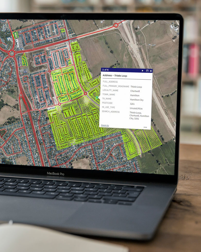
Rich data sourcesIncluding greenfield developments (plann...Including greenfield developments (planned subdivisions), roading changes, land-use areas, points of interest, building consents, title records and address updates from infrastructure providers

Flexible deliveryAvailable via a range of delivery channe...
Flexible deliveryAvailable via a range of delivery channe...Available via a range of delivery channels, from individual data files through to enterprise-grade data sharing platforms such as Snowflake


Explore a sample of NZ MasterMap data through our interactive portal and experience for yourself how it can support smart decision-making


Essential spatial data for a comprehensive overview of New Zealand
NZ MasterMap is trusted where physical address and location accuracy are most critical; for organisations and businesses that need to get people, services and products to a physical location, or who need to understand proximity and location based risks.
The insurance sector leverages NZ MasterMap’s hazard and risk data to help assess property risks and assist in policy validation processes.
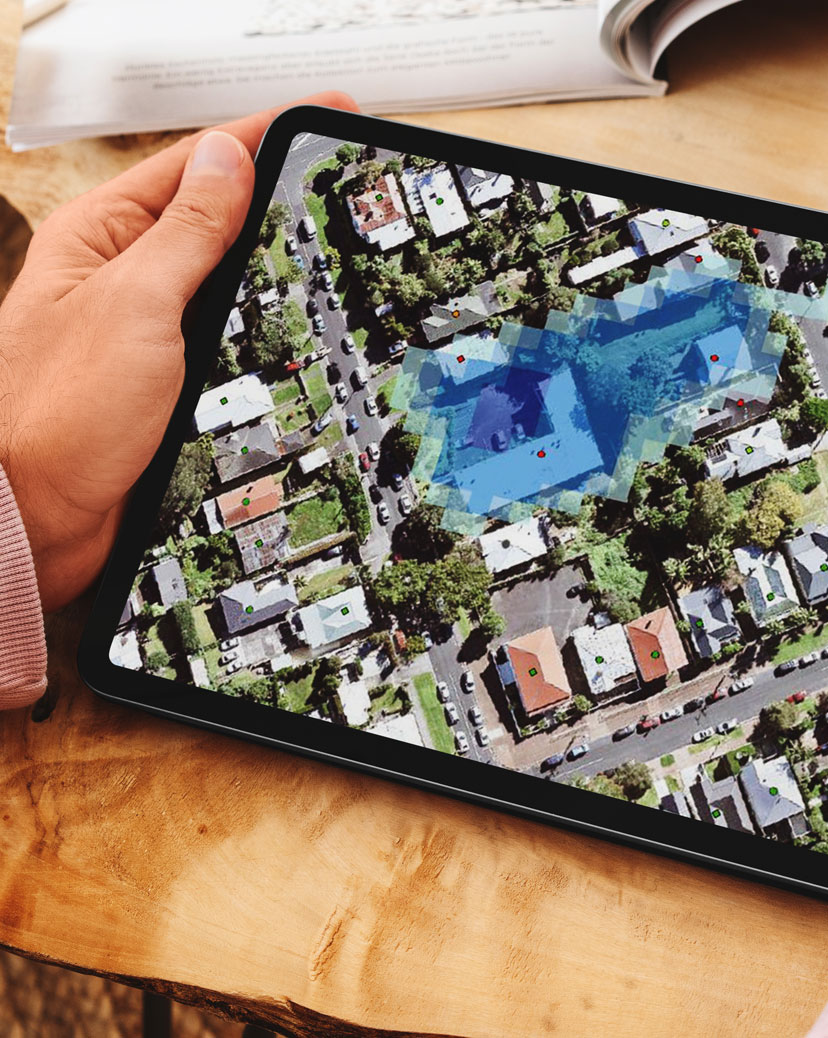
Because address points in MasterMap are mostly located over the main dwelling of the property (as opposed to centre front of parcel or parcel centroid), risks to property, such as flooding can be more accurately assessed, as a few metres deviation can make a big difference to estimated flood depths
New Zealand government policy makers and planners rely on NZ MasterMap to help them to better understand infrastructure needs and to assist with the coordination of essential services and emergency responses.
NZ MasterMap offers access to a greater level of detail that is designed to help support more accurate planning by showing with greater precision where properties are located (where other mapping systems typically have the address point located on the letterbox or the centre of the piece of land for example, but not necessarily where the house is located). This can help identify the extent to which the property will be impacted by an event.
This methodology is also designed to help first responders when responding to call outs by providing them with a greater level of detail about the property they’re going to, as well as the quickest route to the property.
NZ Master Map helps telecommunications providers get the information they need to deliver high-speed broadband connections to customers across New Zealand. CoreLogic matches fibre availability data across all our available physical address points. This can help:
- internet service providers to offer customers the most appropriate pricing and services for their property
- customers to self-serve packages and pricing via the ISP’s website
- ensure hardware is delivered to the correct address
Essential spatial data for a comprehensive overview of New Zealand
NZ MasterMap is trusted where physical address and location accuracy are most critical; for organisations and businesses that need to get people, services and products to a physical location, or who need to understand proximity and location based risks.
The insurance sector leverages NZ MasterMap’s hazard and risk data to help assess property risks and assist in policy validation processes.
Because address points in MasterMap are mostly located over the main dwelling of the property (as opposed to centre front of parcel or parcel centroid), risks to property, such as flooding can be more accurately assessed, as a few metres deviation can make a big difference to estimated flood depths
New Zealand government policy makers and planners rely on NZ MasterMap to help them to better understand infrastructure needs and to assist with the coordination of essential services and emergency responses.
NZ MasterMap offers access to a greater level of detail that is designed to help support more accurate planning by showing with greater precision where properties are located (where other mapping systems typically have the address point located on the letterbox or the centre of the piece of land for example, but not necessarily where the house is located). This can help identify the extent to which the property will be impacted by an event.
This methodology is also designed to help first responders when responding to call outs by providing them with a greater level of detail about the property they’re going to, as well as the quickest route to the property.
NZ Master Map helps telecommunications providers get the information they need to deliver high-speed broadband connections to customers across New Zealand. CoreLogic matches fibre availability data across all our available physical address points. This can help:
- internet service providers to offer customers the most appropriate pricing and services for their property
- customers to self-serve packages and pricing via the ISP’s website
- ensure hardware is delivered to the correct address
Essential location data at your fingertips
NZ MasterMap provides the spatial data that powers a range of our products and solutions, including:


Essential location data at your fingertips
NZ MasterMap provides the spatial data that powers a range of our products and solutions, including:
AddressRight offers accurate, up-to-date address data that’s ready to be integrated into your website and internal systems, saving time and money while supporting a great customer experience.
eMap is our map-based property research platform. It brings together interactive online maps and high-resolution imagery with New Zealand’s most comprehensive property and spatial data.
NZ FloodMap is designed to provide a consistent spatial view of flood risk across New Zealand, for both large areas and individual properties.